摘要:【目的】分析伊犁河流域草地地上生物量(Above ground biomass,AGB)的演变,为合理利用该草地提供科学依据。【方法】采用1990\~2022年Landsat数据与实测数据相结合,构建伊犁河流域草地AGB反演模型,分析该流域及流域内10个县(市)草地AGB时空演变特征及其稳定性,并运用趋势分析和 F 显著性检验揭示草地的历史演变规律。【结果】在建立的回归模型中,二次函数反演模型精度最高,其验证精度为7 1 . 2 2 % ,可用于伊犁河流域草地AGB反演;在时间变化上,1990\~2022年伊犁河流域草地AGB呈现波动增加趋势,从1990年的  增加到2022年的
  ,增长速率为
  ,其中新源县增加速率最快,为
  ;霍尔果斯市增加速率最慢,为
  。在空间变化上,东部新源县、尼勒克县,南部巩留县、昭苏县及北部伊宁县偏高,西部霍城县、察布查尔锡伯自治县偏低的分布格局;在变化趋势上,伊犁河流域草地AGB主要以改善为主,占草地总面积的 5 9 . 6 7 % 。【结论】近33年来伊犁河流域草地AGB呈现出“大部改善,局部稳定,少量退化”的状态,气候的“暖湿化”以及草地保护的完善为草地AGB的改善提供了有利条件。
中图分类号:S812 文献标志码:A 文章编号:1001-4330(2025)02-0463-11
(1.新疆农业大学草业学院/新疆草地资源与生态重点实验室/西部干旱荒漠区草地资源与生态教育部重点实验室,乌鲁木齐830052;2.伊犁哈萨克自治州草原工作站,新疆伊宁835000;3.伊犁哈萨克自治州林业和草原局,新疆伊宁835000)
0引言
【研究意义】草地地上生物量(Abovegroundbiomass,AGB)不仅可反映植被的生长状况、表征草地的生产潜力和载畜能力[1],亦是陆地生态系统碳库的主要组成部分[2,在草地生态系统中起着重要作用[3]。遥感技术的发展为草地AGB的研究提供了新的方法[4],具有重复周期短、覆盖范围广、数据源丰富、节约成本等优势,在草地AGB动态监测中得到了广泛应用[5]。常用的遥感数据源有Modis、Landsat等,其中Landsat空间分辨率更高,能够更准确地反演地面参数并体现其空间变化规律[6],在草地AGB 监测中较广泛的应用[7-9]。研究草地AGB 的演变,对于解释草地植被变化、制定适宜的草地载畜量、分析及评价区域生态环境具有重要意义[10-i]。【前人研究进展】目前,关于草地AGB的研究多集中在不同区域的时空分布特征和趋势分析等方面。前者基于长时序数据,对不同区域内的草地AGB时空变化进行分析,受自然因素与人为因素的影响,时间上呈现波动增加或减少的变化规律[5,12-13],空间上呈现出不同的分布格局[14-15]。后者则采用趋势分析法,利用长时间序列数据进行回归分析,研究不同像元内草地AGB的变化[16],其结果可以阐明一定时间内,该区域内的草地是处于改善、退化还是稳定的状态[17-19]。【本研究切入点】伊犁河流域东、北和南三面环山,草地植被发育良好,类型丰富,是新疆优质畜牧业生产基地。但目前草地无论在数量上,还是质量上均出现一定程度的退化[20-22]。需研究伊犁河流域草地 AGB 时空演变。【拟解决的关键问题】基于Landsat影像并结合实测数据建立反演模型,得到伊犁河流域1990~ 2 0 2 2 年生长期最大草地AGB数据集,采用回归分析、变异系数法分析伊犁河流域草地AGB时空演变特征及其空间稳定性,并采用slope趋势分析和 F 检验分析探讨其草地AGB演变规律,为了解伊犁河流域草地生长状况及变化趋势提供依据。
材料与方法
1.1 材料
1. 1. 1 研究区概况
伊犁河流域位于伊犁哈萨克自治州(  E~
E~  E,
E, 
 ,流域面积
,流域面积  。流域内多种地貌类型并存,地势东高西低,东窄西宽,最高海拔
  ,最低海拔 5 3 2 m 。受地貌影响,流域内降水丰富,形成了西北干旱半干旱区独特的“湿岛”气候。年均气温
  ,年均降水量
  。由于流域整体较为湿润,植被发育良好,是我国西北部重要的农牧业基地[23] 。
1. 1.2 实测数据
地面实测样本数据于2022年8月野外获取。样地及样方布设采取典型取样法在样点附近选取符合整体样地特征和未被家畜采食地区布设,总计布设321个样地。其中,在以草本、半灌木及矮小灌木为主的样地内布设3个 1 m × 1 m 的样方;在以灌木及高大草本植物为主的样地内布设1个 的灌木及高大草本植物样方和3个1m× 1 m 的草本、半灌木及矮小灌木样方。采用齐地面刘割法,分种测定植物地上生物量鲜重,总计963个样方。
1. 1.3 遥感数据
基于GoogleEarthEngine(GEE)遥感云计算平台得到研究区 1 9 9 0 ~ 2 0 2 2 年Landsat 3 0 m 逐年4\~10月归一化植被指数(NormalizedDiffer-enceVegetationIndex,NDVI)最大值数据集。该数据集是基于美国陆地卫星Landsat5、landsat8和Landsat9遥感影像,利用最大值合成法计算得到的。
1.2 方法
1.2.1 AGB模型的建立
采用 70 % 的样地建立模型, 30 % 的样地用于精度验证。利用ArcGIS提取各样本点的 N D V I 建立生物量的线性及非线性反演模型,5种模型为线性函数模型( y = a x + b )、二次函数模型( y =  )、指数函数模型
  )幂函数模型
  )及对数函数模型(
 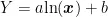 。
。
1.2.2 精度验证
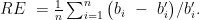
选取平均相对误差(  )、均方根误差(RMSE)、估算模型精度(Accuracy)评价模型精度。

式中, n 为样本数,  为实测生物量,
  为实测生物量的平均,
  为估测生物量。
1.2.3 AGB时空演变
(1)草地AGB时空变化特征
将研究期划分为 1 9 9 0 ~ 1 9 9 5 年 . 1 9 9 6 ~ 2 0 0 0 年 . 2 0 0 1 ~ 2 0 0 5 年  年
年  年和 2 0 1 6 ~ 2 0 2 2 年6个时间段,利用ArcGIS波段集统计处理其数据集,分析其草地AGB空间变化。
(2)AGB变异系数
利用变异系数(CoefficientofVariation, C V ) 描述 1 9 9 0 ~ 2 0 2 2 年草地AGB的相对波动程度[24]

式中, C V 是变异系数, σ 是标准差,  是AGB的平均值。
用聚类分析将变异系数划分为小、较小、中、较大和大  个波动等级。表1
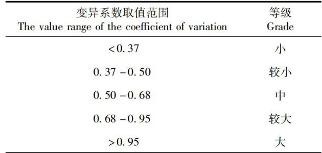 表1AGB变异系数分级 Tab.1 AGBcoefficient of variationclassification
1.2.4 AGB变化趋势
利用slope趋势分析及 F 检验分析草地AGB在时间尺度上的变化趋势,其中slope表示研究区每个像元内草地AGB的变化趋势。当 s l o p e gt; 0 时,表示该像元内草地AGB呈增加趋势;反之,则表示该像元内草地AGB呈退化趋势,计算公式[21]及趋势划分[26]。表4

 (5)
(5)
式中, i 为年序号,  为第
为第  年的 A G B 值, n 为样本量。slope是 A G B 在研究时间内的变化率。表2
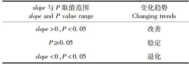 表2 AGB变化趋势分级Tab.2 Grading of AGBchangetrends
2 结果与分析
2.1 草地生物量反演
研究表明,NDVI的二次函数模型最佳,其均方根误差(RMSE)和平均相对误差 ( R E ) 均为最小,分别为  和 1 . 1 4 % ;决定系数
  和精度最高,分别为0.90和 7 1 . 2 2 % ,模型较为可靠。表3
实测草地AGB和遥感反演AGB相关性  达0.90,平均相对误差和均方根误差分别为 7 . 5 9 % 和
  ,模型精度达 6 9 . 1 1 % 。以二次函数模型建立的NDVI和地上生物量估测值与实测值较为接近,可以用于估测伊犁河流域草地AGB。图1
 图1 实测草地AGB与预测AGB的关系 Fig.1 Relationshipbetweenmeasured andpredictedgrasslandAGB
 表3不同植被指数的伊犁河流域草地AGB反演模型Tab.3AGB inversion model of grassand in Ii River basin with different vegetation indexes
2.2 草地AGB时空变化特征
2.2.1 时间变化特征
研究表明, 1 9 9 0 ~ 2 0 2 2 年伊犁河流域草地
AGB整体呈波动增加趋势,增长速率为 
 。其最小值出现在1995年,为
 ;最大值出现在2006年,为
  。在6个时间段中, 1 9 9 6 ~ 2 0 0 0 年和 2 0 1 1 ~ 2 0 1 5 年为快速上升阶段,上升速率分别为35.43和17.29
 5 1 9 9 0 ~ 1 9 9 5 年和 2 0 0 1 ~ 2 0 0 6 年为缓慢上升阶段,上升速率为0.17和
  ·a);而 2 0 0 6 ~ 2 0 1 0 年和 2 0 1 6 ~ 2 0 2 2 年为波动下降阶段,下降速率分别为20.25和
  :a);
:a);
1 9 9 0 ~ 2 0 2 2 年伊犁河流域各县(市)草地AGB均呈波动增加趋势,其中新源县增加速率最大,为  ;霍尔果斯市增加速率最小,为
  ;其余县(市)增长速率依次为巩留县
  尼勒克县(
尼勒克县(  ) gt; 察布查尔锡伯自治县(8.22
 ) gt; 特克斯县
  伊宁县
伊宁县  昭苏县
昭苏县  a)) gt; 霍城县
  ) gt; 伊宁市(4.34
 )。图2\~3
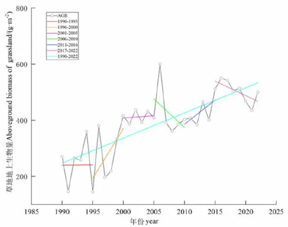 图2 1 9 9 0 ~ 2 0 2 2 年伊犁河流域草地AGB变化特征
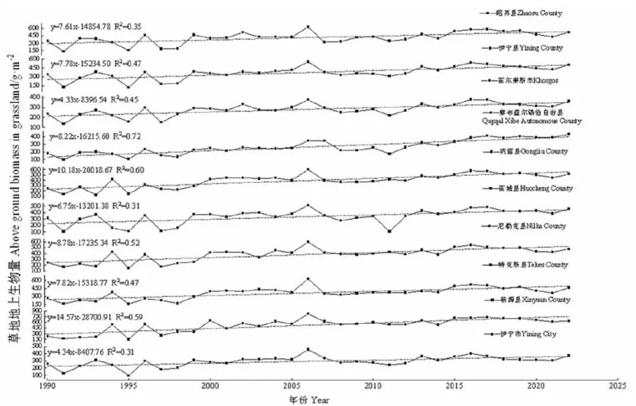 图3 1990\~2022年伊犁河流域各县市草地AGB变化特征Fig.3AGB change characteristics of grassland in Ili River basin from 199O to 202:
2.2.2 空间变化特征
研究表明, 1 9 9 0 ~ 2 0 2 2 年,伊犁河流域草地AGB空间上呈现东部、南部和北部山区偏高,西部、中部河谷偏低的空间分布格局。其中, 1 9 9 0 ~ 2000年,绝大部分草地AGB在  ,占草地总面积的 91 % : 2 0 0 1 ~ 2 0 2 2 年,草地AGB逐渐增加。生物量大于
  的地区占比从1 9 9 0 ~ 1 9 9 5 年的 0 . 2 1 % 增加到 2 0 1 6 ~ 2 0 2 2 年的2 6 . 6 2 % ,生物量高的草地主要分布在东部那拉提山、南部哈克他乌山和北部科古琴一婆罗科努山等山区。图4
1 9 9 0 ~ 2 0 2 2 年伊犁河流域草地AGB主要集中在  ,占全流域草地面积的4 2 . 7 1 % ,在各县(市)均有分布;其次为 3 0 0 ~ 6 0 0
  ,占比 3 3 . 2 5 % ,各县(市)皆有分布;第三为
 ,占比为 2 3 . 8 3 % ,主要分布在昭苏县、特克斯县、新源县,尼勒克县、霍城县、巩留县以及伊宁县海拔
  的山区。表4
注:审图号:GS(2009)1822号,底图边界无修改,下同
Notes:Review Drawing Number:GS(2O09)1822 Number,No modification to map boun daries,the same as below
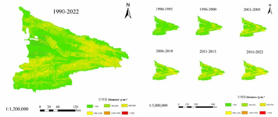 图4 1990~2022年伊犁河流域草地AGB空间分布Fig.4Spatial distribution of grassland AGB in Ili River basin from199O to 2022
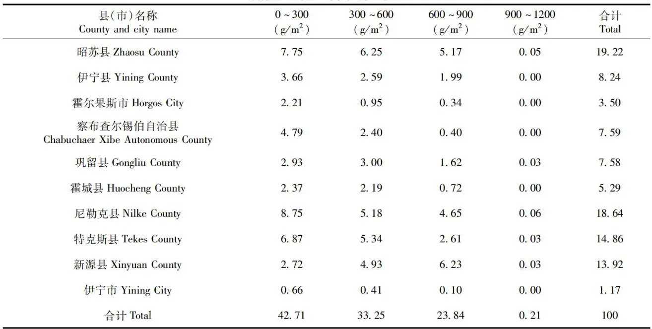 表41990~2022年伊犁河流域各县(市)草地AGB面积占比Tab.4Proportion of grassland AGB area incountiesand cities of IliRiverbasin from1990to2022
1 9 9 0 ~ 2 0 2 2 年伊犁河流域草地AGB变异系数整体较低,处于较为稳定的状态。 1 9 9 0 ~ 1 9 9 5 年,草地AGB变异系数相对较大,变异系数低或较低的草地面积占比为 4 7 . 8 2 % ,主要分布在中西部地区;中度变异的草地占比为 2 7 . 6 3 % ,主要分布在中西部及北部地区;变异系数高和较高的草地占比 2 4 . 5 5 % ,主要分布在东部地区。33年间,变异系数高和较高的草地占比逐渐降低,由1 9 9 0 ~ 1 9 9 5 年的 2 7 . 6 3 % 降低到 2 0 1 6 ~ 2 0 2 2 年的 2 . 7 1 % ;变异系数低和较低的草地占比由1990\~1995年的 4 7 . 8 2 % 逐渐增加 2 0 1 6 ~ 2 0 2 2 年的到 9 3 . 5 9 % ,草地趋于稳定状态。
1 9 9 0 ~ 2 0 2 2 年变异系数低变和较低的草地占比较大,为 7 2 . 0 2 % ,在伊犁河流域各县(市)均有分布;中等变异的草地占比 2 1 . 7 0 % ,主要分布在霍城县中部、特克斯县北部以及昭苏县中部、新源县东部山区;变异系数较高和高的草地占比7 . 2 8 % ,主要分布在察布查尔锡伯自治县北部、巩留县中部河谷,以及尼勒克县西南部山区。1990~ 2 0 2 2 年33年间各县(市)草地AGB变异系数较小,草地AGB较为稳定。图5,表5
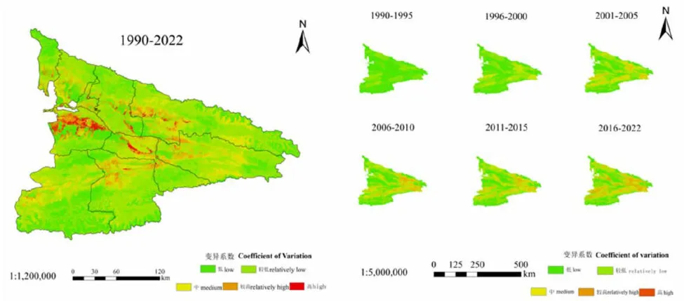 图5 1 9 9 0 ~ 2 0 2 2 年伊犁河流域草地AGB变异系数空间分布Fig. 5 Spatial distribution of AGB variation coefficient of grassland in IliRiverbasinfrom1990to2022
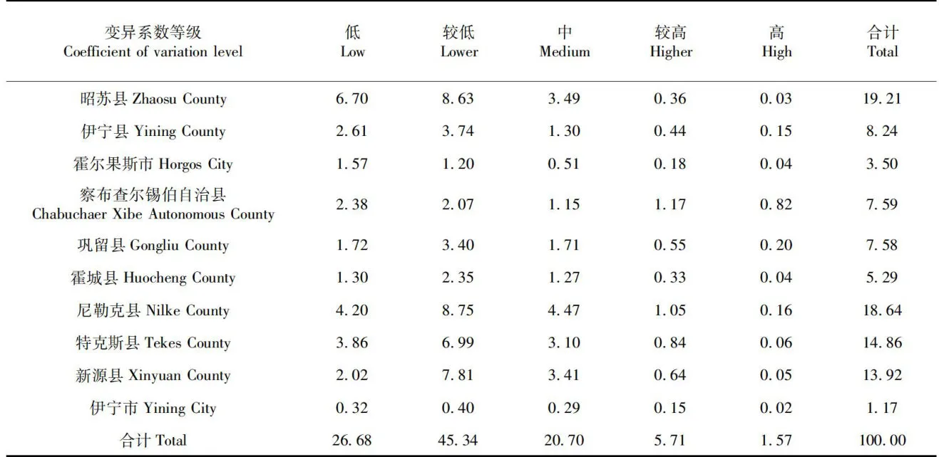 表5 1 9 9 0 ~ 2 0 2 2 年伊犁河流域各县(市)草地AGB变异系数面积占比Tab.5Proportion of grassland AGB coefficient of variation area in counties or citiesinIliRiverbasinfrom199Oto2022
2.2.3 趋势分析及显著性检验
研究表明, 1 9 9 0 ~ 2 0 2 2 年伊犁河流域大部分草地AGB处于稳定状态。其中, 1 9 9 0 ~ 2 0 1 5 年,伊犁河流域绝大部分草地AGB都趋于稳定,占比9 3 . 3 0 % ~ 9 7 . 9 6 % ;处于退化草地AGB的占0 . 8 8 % ~ 5 . 6 1 % ;处于改善的草地AGB占比较少,在 0 . 6 1 % ~ 2 . 4 4 % 。 2 0 1 6 ~ 2 0 2 2 年,处于稳定的草地占比 8 1 . 9 7 % ,而退化草地占比1 6 . 1 3 % ,主要分布在中部及南部地区;改善草地占比 1 . 9 % ,零星分布在北部地区。图6
33年来伊犁河流域草地AGB主要以改善为主,占总草地面积的 5 9 . 6 8 % ,各县(市)均有分布;其次为稳定草地,占比为 2 7 . 6 6 % ,分布于各县(市);退化草地占比为 1 2 . 6 6 % ,主要分布在昭苏县、特克斯县和新源县南部高海拔地区,伊宁县东南部,尼勒克东部、北部和西南部山区以及霍城县河谷。表6
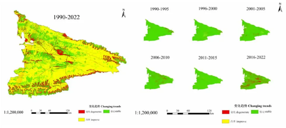 图6 (204 1 9 9 0 ~ 2 0 2 2 年伊犁河流域草地AGB变化趋势Fig.6Analysis of change trend of grassland AGB in Ili River basin from 199O to 202
 表6 1 9 9 0 ~ 2 0 2 2 年伊犁河流域各县(市)草地AGB变化趋势面积占比Tab.6Proportion of grassland AGB change trend area in counties and cities ofIli Riverbasinfrom1990 to2022(%)
3讨论
3.1杨淑霞等[5]、Zeng等[27]、乐荣武等[28]对不同草地AGB的时间变化特征的研究均发现,草地AGB随时间的变化呈现波动增加趋势,与研究结果相似。研究在探讨伊犁河流域各县(市)草地AGB变化时发现,各县(市)草地变化与伊犁河流域总体变化一致,均呈现波动上升趋势,与刘亮等[29对 2 0 0 8 ~ 2 0 1 8 年伊犁河流域年际植被NPP随时间变化总体呈现波动上升趋势结果一致。区域气候变暖已报道为草地AGB增长的驱动因素[27-28]。伊犁河流域气候变暖[30-33]可能促进了该区域草地AGB的增长,通过增温增加植物光合酶的活性加速光合作用的生化反应,使得光合速率提高并且延长植物的生长季[34-35]。此外,由于该区域拥有独特的地理位置和海拔高度,温度升高可能增加山地冰川融水,产生的地表径流作为可利用水的重要来源,促进该地区草地植被的生长。降水是影响草地生长速率的关键因素,降水量增加能够促进植被生物量积累[36]。新源县降水量最高,而霍尔果斯市降水量最低,可能是造成新源县草地AGB增长速率最快,而霍尔果斯市增长速率最慢的主要原因。在2016~2022年间伊犁河流域降水量呈现下降趋势[37],可能是导致生物量在此时间段内呈现波动下降趋势的主要原因。
3.2空间特征上,伊犁河流域草地AGB总体呈现东部、南部和北部偏高,西部、中部偏低的空间分布格局,与孙国军等[32]对 2 0 0 0 ~ 2 0 1 5 年伊犁河谷植被覆盖空间特征相似。河谷区的降水量较小,而山区的降水量较大。因此,中西部低海拔区植被稀疏,而北部、东部、南部海拔较高的山谷地带植被丰富,草地AGB高[38-39] 。
3.3杨淑霞等[5]、王公鑫等[40]对不同时序、地区的草地AGB进行趋势分析,发现草地AGB变化趋势以改善为主,与试验研究的伊犁河流域草地AGB主要以改善( 5 9 . 6 7 % )为主结果相似,主要是因为气候变化及人类活动限制草地AGB增长[41-43]。由于新疆气候出现“暖湿化\"现象[44]且草原生态补偿政策[45-46],使得草地得以恢复,草地AGB得以改善。
4结论
4.1最佳模型为NDVI的二次函数模型,其平均相对误差和均方根误差均最小,分别为 7 . 5 9 % 和 ,决定系数和精度最高,分别为0.90和 6 9 . 1 1 % ,此模型可用于监测伊犁河流域的草地AGB变化。
4.2 1 9 9 0 ~ 2 0 2 2 年伊犁河流域草地 AGB总体呈现波动增加趋势,波动范围为 1 4 4 . 5 3 ~ 6 0 1 . 4 0  ,增长速率为
  。伊犁河流域各县(市)草地AGB变化与流域总体变化一致,均呈现波动增加趋势,其中新源县增加速率最快,为
  ;霍尔果斯市增加速率最慢,为
  。
。
4.3伊犁河流域草地AGB呈出东部、南部和北部山区偏高,西部、中部河谷偏低的空间分布格局。草地AGB较高的主要分布在昭苏县、特克斯县、新源县,尼勒克县、霍城县、巩留县以及伊宁县海拔  的山区。草地AGB变异系数整体较小(低或较低占比 7 1 . 5 4 % ),且呈降低趋势,草地趋于稳定状态。
4.4近33年来伊犁河流域草地AGB呈稳定改善趋势。
参考文献(References)
[1]WhiteRP,MurrayS,RohwederM,etal.Pilotanalysisofglobalecosystems:grassland ecosystems  .Washington,D.C.:WorldResources Institute,2000.
[2]YangYH,FangJY,PanYD,etal.Aboveground biomass inTibetan grasslands[J]. Journal of Arid Environments,2009,73(1):91-95.
[3]杨荣荣,兰垚,张卓.中国近30年草地地上生物量的研究进展[J].亚热带水土保持,2019,31(2):38-41,48.YANG Rongrong,LAN Yao, ZHANG Zhuo. Study progress onthe ground biomass of grassand with 3O years in China[J]. Sub-tropical Soil and WaterConservation,2019,31(2):38-41,48.
[4]于惠,吴玉锋,金毅,等.基于 MODIS SWIR数据的干旱区草地地上生物量反演及时空变化研究[J].遥感技术与应用,2017,32(3):524-530.YUHui,WUYufeng,JINYi,etal.Anapproach for monitoringthe aboveground biomass of grassland in arid areas based on MO-DIS SWIR bands[J]. Remote Sensing Technology and Applica-tion,2017,32(3): 524-530.
[5]张静宇,史击天,张群.遥感技术在北京市农业统计中的应用现状[J].宁夏农林科技,2012,53(4):110-112.ZHANG Jingyu,SHI Jitian, ZHANG Qun.Application of remotesensing technology in agriculture-statistics in Beijing[J].Ningxia Journal ofAgriculture and Forestry Scienceand Technolo-gy,2012,53(4):110-112.
[6]Meng B P,Ge J,Liang TG,et al. Evaluation of remote sensinginversion error for the above-ground biomassof alpine meadowgrassand based on multi -source satelite data[J].Remote Sens-ing,2017,9(4) : 372.
[7]赵越,徐大伟,范凯凯,等.Landsat8和机器学习估算蒙古高原草地地上生物量[J].农业工程学报,2022,38(24):138-144.ZHAO Yue, XU Dawei, FAN Kaikai,et al. Estimating above -ground biomass in grassland using Landsat 8 and machine learningin Mongolian plateau[J]. Transactions of the Chinese Society ofAgricultural Engineering,2022,38(24):138-144.
[8]李莹,张勇娟,靳瑰丽,等.基于Landsat 数据的乌鲁木齐市草地地上生物量时空演变及趋势分析[J].草地学报,2023,31(7):1950-1963.LI Ying,ZHANG Yongjuan,JIN Guili,et al. Temporal andspatial evolution and trend analysis on the grassland above groundbiomass in Urumqi based on landsat data[J]. Acta Agrestia Sini-ca,2023,31(7) : 1950-1963.
[9]张雅,尹小君,王伟强,等.基于Landsat8OLI遥感影像的天山北坡草地地上生物量估算[J].遥感技术与应用,2017,32(6):1012-1021.ZHANG Ya, YIN Xiaojun,WANG Weiqiang, et al. Estimationof grassland aboveground biomass using landsat 8 OLI satelite im-age in the northern hilside of Tianshan Mountain[J].RemoteSensing Technologyand Application,2017,32(6):1012-1021.
[10]赖炽敏,赖日文,薛娴,等.基于植被盖度和高度的不同退化程度高寒草地地上生物量估算[J].中国沙漠,2019,39(5):127 -134.LAI Chimin,LAI Riwen,XUE Xian,et al. Estimation ofaboveground biomassofdifferentdegradedalpine grasslandbasedon vegetation coverage and height[J]. Journal of Desert Research,2019,39(5):127-134.
[11]杨淑霞,冯琦胜,孟宝平,等.三江源地区高寒草地地上生物量时空动态变化[J].草业科学,2018,35(5):956-968.YANG Shuxia,FENG Qisheng,MENG Baoping,et al.Tempo-ral and spatial dynamics of alpine grassland biomass in the Three-RiverHeadwaterRegion[J].Pratacultural Science,2O18,35(5): 956 -968.
[12]陆荫,杨淑霞,李晓红.甘南州高寒天然草地生长状况遥感监测[J].草业科学,2021,38(1):32-43.LUYin,YANG Shuxia,LI Xiaohong.Monitoring of grasslandherbage accumulation by using remote sensing in Gannan Prefec-ture[J]. Pratacultural Science,2021,38(1) : 32-43.
[13]王秀梅,董建军.基于广义线性模型估算内蒙古荒漠草原及典型草原地上生物量变化[J].草地学报,2020,28(6):1711 -1718.WANG Xiumei,DONG Jianjun. Estimation of the abovegroundbiomass of desert steppe and typical steppe in Inner Mongolia u-sing generalized linear model[J].Acta Agrestia Sinica,2020,28(6): 1711-1718.
[14]GeJ,HouMJ,LiangTG,etal.Spatiotemporal dynamics ofgrassland aboveground biomass and its driving factors in NorthChina over the past 2O years[J]. Science of the Total Environ-ment,2022,826:154226.
[15]YuH,WuYF,NiuLT,et al.A method to avoid spatial over-fiting in estimation of grassand above- ground biomass on the Ti-betanPlateau[J].Ecological Indicators,2021,125:107450.
[16]张建云,张成凤,鲍振鑫,等.黄淮海流域植被覆盖变化对径流的影响[J].水科学进展,2021,32(6):813-823.ZHANG Jianyun, ZHANG Chengfeng,BAO Zhenxin, et al. A-nalysis of the effects of vegetation changes on runoff in the Huang- Huai-Hai River basin under global change[J]. Advances inWater Science,2021,32(6):813-823.
[17]宋瑞玲,王昊,张迪,等.基于 MODIS-EVI评估三江源高寒草地的保护成效[J].生物多样性,2018,26(2):149-157.SONG Ruiling,WANG Hao, ZHANG Di,et al. Conservationoutcomes assessment of Sanjiangyuan alpine grassland with MODIS-EVIapproach[J].Biodiversity Science,2018,26(2):149-157.
[18]陈琪,赵健,杨九艳,等.荒漠草场地上生物量的遥感监测——以内蒙古阿拉善盟为例[J].中国草地学报,2020,42(2): 105 -116.CHEN Qi, ZHAO Jian,YANG Jiuyan,et al. Remote sensingmonitoring of biomass on desert grassland:a case study of Alxaleague in Inner Mongolia[J].ChineseJournal of Grassland,2020,42(2):105-116.
[19]张玉琢,杨志贵,于红妍,等.基于STARFM 的草地地上生物量遥感估测研究——以甘肃省夏河县桑科草原为例[J].草业学报,2022,31(6):23-34.ZHANG Yuzhuo,YANG Zhigui,YU Hongyan,et al.Estimatinggrassland above ground biomass based on the STARFM algorithmand remote sensing data-a case study in the sangke grassland inXiahe County,Gansu Province[J].Acta Prataculturae Sinica,2022,31(6):23-34.
[20]王宏伟,张小雷,乔木,等.基于GIS 的伊犁河流域生态环境质量评价与动态分析[J].干旱区地理,2008,31(2):215-221.WANG Hongwei, ZHANG Xiaolei, QIAO Mu, et al. Assessmentand dynamic analysis of the eco -environmental quality in the liRiver Basin based on GIS[J]. Arid Land Geography,2008,31(2):215-221.
[21]赵丽,杨青,韩雪云.1961-2009年伊犁地区降水指数的时空分布及变化特征分析[J].干旱区资源与环境,2014,28(10):82-89.ZHAO Li, YANG Qing, HAN Xueyun. Analysis of temporal andspatial distributionand variation characteristics of precipitation in-dex in Ili during 1961-2009[J]. Journal of Arid Land Resourcesand Environment,2014,28(10) : 82-89.
[22]杨阳,张红旗.近20年来伊犁新垦区土地利用/覆被变化分析[J].资源科学,2009,31(12):2029-2034.YANG Yang,ZHANG Hongqi.Analysis of land useand landcover change in the Yili newly reclaimed area in recent 2O years[J].Resources Science,2009,31(12): 2029-2034.
[23]王颖慧,丁建丽,李晓航,等.伊犁河流域土地利用/覆被变化对生态系统服务价值的影响—基于强度分析模型[J].生态学报,2022,42(8):3106-3118.WANG Yinghui,DING Jianli,LI Xiaohang,etal.ImpactofLUCC on ecosystem services values in the Yili River Basin basedon an intensity analysis model[J]. Acta Ecologica Sinica,2022,42(8) : 3106 -3118.
[24]李传华,赵军,师银芳,等.基于变异系数的植被NPP人为影响定量研究——以石羊河流域为例[J].生态学报,2016,36(13):4034-4044.LI Chuanhua,ZHAO Jun,SHI Yinfang,et al.The impact ofhuman activities on net primary productivitybased on the coeffi-cient of variation:a case study of the Shiyang River Basin[J].Acta Ecologica Sinica,2016,36(13) : 4034-4044.
[25]李卓,孙然好,张继超,等.京津冀城市群地区植被覆盖动态变化时空分析[J].生态学报,2017,37(22):7418-7426.LI Zhuo,SUN Ranhao,ZHANG Jichao,et al. Temporal- spa-tial analysis of vegetationcoverage dynamics in Beijing- Tianjin-Hebei metropolitan regions[J]. Acta Ecologica Sinica,2017,37(22): 7418-7426.
[26]崔博超,郑江华,吐尔逊·哈斯木,等.塔里木河流域草地净初级生产力时空分异特征研究[J].草业学报,2020,29(6):1-13.CUI Bochao, ZHENG Jianghua,Tuerxun Hasimu,et al. Spatio-temporal characteristicsof grasslandnet primaryproductivity(NPP)in the Tarim River basin[J]. Acta Prataculturae Sinica,2020,29(6):1-13.
[27]Zeng N,Ren X L,He HL,etal.Estimating grasslandaboveground biomassontheTibetanPlateauusingarandomforestalgorithm[J].Ecological Indicators,2019,102:479-487.
[28]乐荣武,张娜,王晶杰,等.2000\~2019年内蒙古草地地上生物量的时空变化特征[J].中国科学院大学学报,2022,39(1):21-33.Le Rongwu,ZHANG Na,WANG Jingjie,etal.Spatiotemporalvariation of grassland aboveground biomass in Inner Mongolia from2000 to 2019[J]. Journal of University of Chinese Academy ofSciences,2022,39(1) :21-33.
[29]刘亮,关靖云,穆晨,等.2008-2018年伊犁河流域植被净初级生产力时空分异特征[J].生态学报,2022,42(12):4861 -4871.LIU Liang,GUAN Jingyun,MU Chen,etal.Spatio -temporalcharacteristics of vegetationnet primary productivity in the li Riv-er Basin from 2008 to 2018[J]. Acta Ecologica Sinica,2022,42(12):4861-4871.
[30]Jobbagy E G,Sala OE.Controls of grass and shrubaboveground production in the Patagonian steppe[J]. EcologicalApplications,2000,10(2): 541.
[31]BaiYF,Han XG,Wu JG,et al.Ecosystem stability andcompensatory effects in the Inner Mongolia grassland[J]. Nature,2004,431(7005):181-184.
[32]孙国军,李卫红,朱成刚,等.2000\~2015 年伊犁河谷植被覆盖时空变化特征[J].干旱区地理,2020,43(6):1551-1558.SUN Guojun,LI Weihong,ZHU Chenggang,et al.Spatial-temporal characteristics of vegetation cover in Ili River Valley from2000 to 2015[J]. Arid Land Geography,2020,43(6): 1551-1558.
[33]闫俊杰,陈晨,赵阳,等.基于TINDVI的伊犁河谷草地覆盖变化[J].水土保持研究,2021,28(3):331-339.Yan Junjie,Chen Chen,Zhao Yang,et al.Dynamics of grass-land coverage in IliRiver valley based on TINDVI[J].Researchof Soil andWater Conservation,2021,28(3):331-339.
[34]WhiteMA,Running SW,ThorntonPE.The impact of grow-ing- season length variability on carbon assmilation and evapo-transpiration over 88 years in the eastern US deciduous forest[J].InternationalJournal ofBiometeorology,1999,42(3):139-145.
[35]Piao SL,Fang JY, Zhou L M,et al. Interannual variations ofmonthly and seasonal normalized diference vegetation index (ND-VI)in China from1982 to 1999[J]. Journal of Geophysical Re-search:Atmospheres,2003,108(D14): e2002jd002848.
[36]王明明,刘新平,何玉惠,等.科尔沁沙质草地生物量积累过程对降水变化的响应模拟[J].生态学报,2020,40(11):3656-3665.WANG Mingming,LIU Xinping,HE Yuhui,et al.Simulatingthe response of biomass accumulation process in semi -arid grass-land to changes in precipitation[J]. Acta Ecologica Sinica,2020,40(11): 3656-3665.
[37]仲涛,李漠岩,李建豪,等.伊犁河流域陆表水域面积时空变化及驱动力分析[J].人民长江,2023,54(4):101-107.ZHONG Tao,LI Moyan,LI Jianhao,etal.Spatio- temporalvariation and driving force analysis of water area on land surface inIli River Basin[J].Yangtze River,2023,54(4):101-107.
[38]刘芳,张红旗,董光龙.伊犁河谷草地植被NDVI变化及其降水敏感性特征[J].资源科学,2014,36(8):1724-1731.LIU Fang, ZHANG Hongqi, DONG Guanglong. Vegetation dy-namics and precipitation sensitivity in Yilivalley grassand[J].Resources Science,2014,36(8):1724-1731.
[39]孙国军,李卫红,朱成刚,等.新疆伊犁河谷表层土壤容重的空间变异性分析[J].资源科学,2016,38(7):1222-1228.SUN Guojun,LI Weihong,ZHU Chenggang,et al.Spatial vari-ationanalysisftopsoilbulkensitineYili Valley,Xijiang[J].Resources Science,2016,38(7):1222-1228.
[40]王公鑫,井长青,董萍,等.新疆荒漠草地生物量估算及影响因素研究[J].草地学报,2022,30(7):1862-1872.WANG Gongxin, JING Changqing,DONG Ping,et al. Study onbiomass estimationand influencing factors of desert grasland inXinjiang[J]. Acta Agrestia Sinica,2022,30(7) : 1862-1872.
[41]Liu N,DingY X,PengSZ.Temporal effects of climateonvegetation trigger theresponse biases of vegetation to human activ-ities[J].Global Ecologyand Conservation,2021,31:e01822.
[42]ChenJH,WangYF,SunJ,et al.Precipitation dominantssynergies and trade - ofs among ecosystem services across theQinghai- Tibet Plateau[J]. Global Ecology and Conservation,2021,32:e01886.
[43]Zhang J,Fang SB,Liu HH. Estimation of alpine grassland a-bove-ground biomass and its response to climate on the Qinghai-TibetPlateau during 2001 to 2019[J].Global Ecology andConservation,2022,35:e02065.
[44]姚俊强,李漠岩,迪丽努尔·托列吾别克,等.不同时间尺度下新疆气候“暖湿化”特征[J].干旱区研究,2022,39(2): 333-346.YAO Junqiang,LIMoyan,Dilinuer Tuoliewubieke,et al.Theassessment on“warming - weting” trend in Xinjiang at multi -scale during 1961-2019[J]. Arid Zone Research,2022,39(2): 333 -346.
[45]恒巴特·阿赛那力,海力且木·斯依提,阿依吐尔逊·沙木西.草原生态补偿政策实施效果评价——以伊犁河谷为例[J].湖北农业科学,2021,60(14):144-147,191.Hengbate Asainali,Hailiqiemu Siyiti,Ayituerxun Shamuxi.Imple-mentation efect evaluation and improvement suggestions of grass-land eco -compensation policies:based on Yili River valley[J].Hubei Agricultural Sciences,2021,60(14):144-147,191.
[46]赵哲,陈建成,王梦,等.中国生态草牧业政策梳理及评价[J].中国农学通报,2019,35(9):132-137.ZHAO Zhe, CHEN Jiancheng,WANG Meng, et al. Ecologicalgrass husbandry in China:analysis and evaluation of the policies[J].Chinese Agricultural Science Bulletin,2019,35(9): 132-137.
Above ground biomass evolution analysis of grassland in Ili River Basin based on landsat imagery
LI Chao1,FAN Tianwen², Tuerxunjiang Ailimubieke²,HE  , LI Jianwei² , WEN
  , ZHANG
  , JIN Guili1,LI
  ,LIU Wenhao1,WANG Shengju1 (1. Xinjiang Key Laboratory of Grassland Resources and Ecology/Key Laboratory of Grassand Resources andEcology in Western Arid Region,Ministryof Education / College of Grastand Science,Xinjiang Agricultural University, Urumqi 830052,China; 2. Grassand Workstation of Ii Kazakh Autonomous Prefecture, Yining Xinjiang 835Oo,China;3. Bureau of Forestry and Grassland of Ili Kazakh Autonomous Prefecture, Yining Xinjiang 835000,China)
Abstract:【Objective】 The evolution analysis of its grassland aboveground biomass (AGB) is of great significance for scientific understanding and rational utilization of grassland.【Methods】The spatio-temporal characteristics and stabilityof grassland AGB in the basinand1O counties and cities in the basin were analyzed,and the historical evolution regularof grassland was revealed bytrend analysis andF-significance test. 【Results】Among the established regression models,the quadratic function inversion model had the highest accuracy with a validation accuracy of 7 1 . 2 2 % ,which could be used for aboveground biomass inversion. From 1990 to 2O22,the AGB of grassand in Ii River basin showed a trend offluctuating increase,from 270.  in 1990 to
  in 2022,with an increase rate of
  , Xinyuan County had the fastest growth rate of
  ,Khorgos City had the slowest increase rate of
  .In terms of spatial variation,the distribution pattern demonstrated a relatively high level in Xinyuan County and NilekeCounty in the east,Gongliu County, Zhaosu County in the south,Yining County in the north,whilea relatively low level in Huocheng County,Qapqal Xibe Autonomous County,and Gongliu County in the west. In terms of the change trend, grassland AGB mainly focusee on improvement,accounting for 5 9 . 6 7 % of the total grassland area.【Conclusion】In general,in the past 33 years,the grassland AGB in Ili River basin has shown a state ofmostly improved,locally stable and slightly degraded.Thewarming and humidification of climate,the improvement and implementation of grassland protection policies have provided favorable conditions for the better grassland AGB.
Key words:Ili River basin;aboveground biomass of grassland; spatio -temporal evolution